How do I define a logic to accurately identify a location on a map
Hello,
I want to create a widget that people can embed in their websites which will show users parking meter regulations at their destination.
I have a database of parking regulations for a city. The data characteristics are as follows:
• The on-street meter parking regulation varies from street to street. Ex: 2300 Market st could have 2hr parking limit on 23rd st and 4hr parking limit on Market st.
• Each regulated street location is listed by an address such as 2300 Market st which represents parking on Market street from 2300 to 2399
• On google map the above listed street representation appears as a point and not a line
• I have geocodes for all the locations
I want to communicate to the driver that the regulation for the entire street on Market st is represented by this address. I'd like to do it in a graphical manner on a map (google map). How do I do that?
I have attached sample data. Nitin-Data.xls
ASKER
You need to put it in the Lat, Long format and not the other way round.
I have not decided which language to use and am open to suggestions. This needs to be available as a webservice so other 3rd party programs can integrate with our API to show parking information in their application. I am thinking of using the REST framework may be CAKE.
The biggest challenge I have now is that I only have the starting position of the street and not the end position. I have attached a map where I have plotted a few regulations but it shows up as a point on the map and not the entire street. Manually drawing a line for each street is going to be very labor intensive and will slow us down tremendously.
Please advice.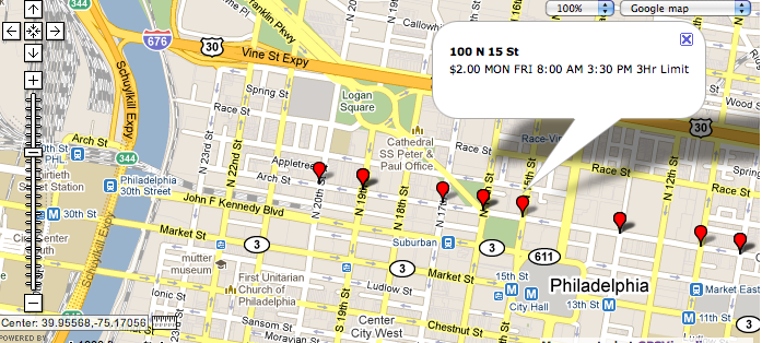
ASKER CERTIFIED SOLUTION
membership
This solution is only available to members.
To access this solution, you must be a member of Experts Exchange.
ASKER
I know about the polyline but what I don't know is what trick to use to represent a street from only the point information I have. Each point info I have represents the start of the street it represents. I want to communicate to the user that the regulation of 3hr limit is for the entire street and not just for that point.
I agree with you on the block based info. When someone is lookiing at the map they should see what the parking regulations are for all the 4-5 streets that appear on their map in a single glance so they can make better decisions.
Please advice.
I agree with you on the block based info. When someone is lookiing at the map they should see what the parking regulations are for all the 4-5 streets that appear on their map in a single glance so they can make better decisions.
Please advice.
I don't know how to do that. Suggest you leave this Q open a while and maybe other experts will weigh in on the question. You might also ask a moderator to add this Q to a language-specific zone here at EE. For example, if you are working in PHP, this Q could be added to the PHP and PHP+Databases zones. There would be a lot more eyes on it there.
ASKER
Where do I make the request to the moderator from.
Thanks
Thanks
Bottom right of the original post at the top of this page. Look for "Request Attention."
ASKER
thanks
SOLUTION
membership
This solution is only available to members.
To access this solution, you must be a member of Experts Exchange.
What programming language are you using to access the data base?