Photos / Graphics Software
--
Questions
--
Followers
Top Experts
Thanks!
Shawn
Zero AI Policy
We believe in human intelligence. Our moderation policy strictly prohibits the use of LLM content in our Q&A threads.
another one : http://www.arcsoft.com/topics/panorama-maker/make-360-panorama.html
and the youtube :
https://www.youtube.com/watch?v=CkH05tYIhyE
Googling around, I did come across a couple of softwares that "seem" to do something like I want:
- 3D Urban Modeller
- www.photomodeller.com
- Autodesk ImageModeller
... but I'm not entirely sure - can you or anyone shed anymore might on that? As I mention in my question subject - I am a complete NEWBIE at 2d and 3d design and I really need to be "led by the hand" and steered in the right direction.
Thanks!
Shawn


EARN REWARDS FOR ASKING, ANSWERING, AND MORE.
Earn free swag for participating on the platform.
Do you own a tripod? what camera do you own?
Is it pluggable to PC.
Is this for web or just personal? as you would need viewers.
As your not sure of what you are asking for how about I give you some examples and then you can critique it and say no yes more less
To give you perspective for web> this is the camera that google uses to take those images that stitch together to create the street view circumference
http://www.google.com.au/maps/about/behind-the-scenes/streetview/
http://www.applied-streetview.com/#applications
Is this going to be using java script/action scripts for a web page ?
Example on the web the viewers required
http://www.panoramas.dk/panorama/viewers.html
Example on the web
Times Square, NYC - New Year's Eve Midnight 2010 - 360VR Images
You can zoom in zoom out scroll L or scroll R move formward and back within the image line.
http://360vr.com/2010/01/2010-times-square-midnight-krpflv/index.html
http://360vr.com/
SLA 3D Virtual gallery – the making of Asia First 3D 360 VR TOUR
http://360vrasia.com/about/solution/
Take the tour virtually
http://www.sla.gov.sg/htm/gallery/SLA_VRtour/SLA_Vrtour.html
How 360vr images are produced.360vr images, here is a a simple explanation page to show you. - See more at: http://www.peterstephens.co.uk/how-are-360vr-images-made.php#sthash.LBbf6F9k.dpuf
Off the web and what I use
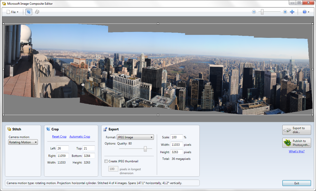
I can create a set of photos stitched together to give a full pan but no tilt using Microsoft Cliplets/ Microsoft Ice (Microsoft Image Composite Editor )
What is Image Composite Editor?
Microsoft Image Composite Editor is an advanced panoramic image stitcher.
Given a set of overlapping photographs of a scene shot from a single camera location, the application creates a high-resolution panorama that seamlessly combines the original images.
The stitched panorama can be shared with friends and viewed in 3D by uploading it to the Photosynth web site.
Or the panorama can be saved in a wide variety of image formats, from common formats like JPEG and TIFF to the multi resolution tiled format used by Silverlight's Deep Zoom and by the HD View and HD View SL panorama viewers.
Power point and my Panorama maker that came with my Camera Nikon.. ArcSoft Panorama maker
Its very good to create full panorama with zoom and pan
There is also power point to created the pan and zoom
Create pan and zoom effects in PowerPoint
http://office.microsoft.com/en-au/powerpoint-help/create-pan-and-zoom-effects-in-powerpoint-HA010232631.aspx
Photo Stitch Software
http://www.easypano.com/photo-stitch-software.html
Ok that should keep you reading and hopefully point you in the right direction of what we can do off the web .
Back to you
Marete, the virtual tour stuff looks pretty much like what I want... in particular the example you point out at :
http://www.sla.gov.sg/htm/gallery/SLA_VRtour/SLA_Vrtour.html
And while googling around last night, I came across the website for Microsoft Photosynth :
http://www.microsoft.com/web/solutions/photosynth.aspx
The virtual tour example on that page is very good. This is very much what I want to do, but I do have a few special constraints. As I mentioned in my opening question, I wish to make a "virtual tour" of the grand market square in Bruges, Belgium.... however here are my special restrictions:
(1) I don't have any of the photos of the buildings involved (and I don't plan on traveling to Belgium anytime soon). I plan to use existing photos that I (hopefully) find on the web (flickr, etc). So therefore all the pics will certainly *not* be taken with the same camera. I don't know if this will be a problem or not.
(2) In order to do my desired "rearranging" of the individual buildings, I feel I need to have a picture of *each* individual building (or at least as many as possible) in the square, and then crop out ONLY that building from the picture. Then after I have accumulated pics of all the individual buildings, somehow "stitch" them together side-by-side in my own desired order. The thing with that is that there will be no "common points" or "overlap" whatsoever between my individual building photos - they just need to be tacked together ("smooshed" together?) side-by-side... even though there's no overlap. This might give a sloppy looking end result, but i cannot think of any other way. This however, I think, would actually work alright for the Bruges square as the existing buildings in the square are already immediately next to one another with zero space in between.
(3) I made a very very crude drawing (attached) that basically outlines how I wish to layout my "virtual square". It's actually a very large rectangular area - maybe the size of a couple of soccer fields... with building facades all around the perimeter. The long red line in the middle shows how I'd like the "path" of the virtual tour to be - basically just left to right and back again... and at each point along the line being able to pan around 360 degrees to see what's ahead, what's to the left, what's to the right, and what's behind. Nothing too fancy really.
So do you think this is do-able Marete??
Thank You!
Shawn
yes I know of photosynth
do I think it's doable with your sets? I'm not really sure, possibly with some tinkering.
Stretching my brain cells here
I know in windows moviemaker and any video editor when creating a slideshow of just photos I can add transitions like pan and zoom to each individual image making it seem like we are moving in and out and around the single photo.
lets say for example if you put together a set of images just buildings in moviemaker and add the pan and zoom effect it works fine,
as you want interactive using the keys they provide I'd say it could be possible using the software provided with photosynth, but if from what I see you need to stitch them first using MS Ice no it won't.
Example of pan and zoom in WMM, I made just a very video illistrate
https://www.dropbox.com/s/u79yb5e5i0l8tti/pan%20and%20zoom.mp4?dl=0
When you look at photosynth example it is similar but in order to get that smooth flow on they have stitched together a few photos using Microsoft Ice, I can see the black border lol, If you can get your images to stitch together it should be fine.
Example of how MS Ice has been used
https://photosynth.net/ice.aspx
from my experience with panorama and Microsoft Ice and any of my Panorama software it wont work if the images don't allign, I have to take so many for a full 360 degrees
When the images are not correctly over lapping they will not stitch/tack together I think you will be stumped from the start if you cannot take all the images required with the correct alignments over lay aspects.
For just a small panorama not a full 360 I may take around 20 images. Then drop them onto MS Ice and stitch them
Like this
 I fix the dark area out by tilting it or modifying the frame.
So I'd say try and stitch your images together using MS Ice.
That's your key, if you can get that to work your good to go with the next steps on Photosynth.
I ran a test of using 4 images from the brief video I made above,
I simply drag dropped them onto MS Ice and tried to stitch them with the rotating motion, no go. It only sees one image at a time and it plays like a slideshow, what we need is to see the 4 images spread out circular.
There is no pan and zoom.
It is amazing how this software knows the images are not linked.
With photosync pan and zoom.
There is a difference between a panorama and and a synth that is the question.
What is Photosynth?
https://photosynth.net/about.aspx
https://photosynth.net/create.aspx
Get a FREE t-shirt when you ask your first question.
We believe in human intelligence. Our moderation policy strictly prohibits the use of LLM content in our Q&A threads.
What is it Shawn857, the direction of the pan? across the building?
With a panorama the scroll effect is left or right depending if you add tilt
If that's what your implying with your rough outline.
Stitched panorama are wide.
My example would work in photosynth when those directional arrows are applied.
The only thing is I didn't take enough images to make a full 360 degrees.
Rereading
How-to Guide it seems they have everything you need as posted>
This tutorial shows you how to use Microsoft Photosynth to convert a collection of photos into an interactive 360 degree 3D panoramic tour.
Originally created by Microsoft Live Labs, Photosynth is a free service from Microsoft that stitches your digital photos together into a 3D model and provides an interactive viewer for exploring the model in detail. [The viewer requires Microsoft Silverlight™, a free browser plug-in that runs on both Windows and Mac. See this page to get Silverlight™].
http://www.microsoft.com/web/solutions/photosynth.aspx
Yes should work , I haven't tried it as I don't have a web page.
Regards Merete
"What is it Shawn857, the direction of the pan? across the building?"
Imagine the red line in my crude drawing as basically the "track" or "path" that a person viewing my city square would take. He could only walk in a straight line from left to right and back again... where the viewer could - from any point along the track - look left, look right, look forward, or look backwards, or zoom.
You also wrote Merete:
"How-to Guide it seems they have everything you need as posted>
This tutorial shows you how to use Microsoft Photosynth to convert a collection of photos into an interactive 360 degree 3D panoramic tour."
Ahh, this sounds promising. But if my individual photos do not have any "overlap", this will still work?
Merete, I just had a CRAZY (but maybe good) idea - what about the video game simulation "SimCity"?? Maybe I could design my city square within that ? But I know nothing about that game - just that I have seen some very nice original building designs while looking through google images (see attached). My main question about SimCity would be - can I "import" pictures of specific buildings that I wish to render...? Maybe I'll need to post this question again to the Experts Exchange topic that handles games, etc. What do you think?
Thanks!
Shawn
MTS-DeluxeDesigns-1352395-Alcester1.jpg
EARN REWARDS FOR ASKING, ANSWERING, AND MORE.
Earn free swag for participating on the platform.
Yes I understood that to be what you meant. And yes that is what you would achieve.
With>if my individual photos do not have any "overlap", this will still work?<< yes I believe so using Synth,
You'll need to choose synth I believe that way it shouldn't matter. Panorama is stitched together
as they said>
Photosynth offers two styles for creating immersive 3D experiences: panoramas and synths.
Check out the differences between them, and the tools available for creating them.
https://photosynth.net/about.aspx
Well your idea is not that crazy but I’m not sure if you still get some of it.
Since I have few Sim City games, up to Sim City 4 and Sim City 3000 Ultimate??
SimCity 3000 actually does have the Building Arcitect Plus part of Simcity 3000 Unlimited,
I haven't played for ages but if I recall
It allows you to build any kind of building you want for your city.
The Building Architect Plus is the program for designing buildings in SimCity 3000 Unlimited. Its features included designing the exterior, painting the walls, adding details like doors, windows, and inserting props, which stood independently.
I couldn't figure out how to do some of the layers floors etc stuff and would rather just play it but have a look if this is the area of interest for you.
SimCity 3000 Urban Renewal Kit (SC3URK
From Wiki
Required Software
For starters, let's go over the programs involved: SimCity 3000 Urban Renewal Kit (SC3URK) is a program created by Maxis that allows you to design and import your own buildings into SimCity 3000 Unlimited.
It is not included on the SimCity 3000 Unlimited installation disk. Instead, it is available as a separate download from the SimCity website (see the Links section below). You will also need a paint program, such as Windows Paint. << I have Paintshop Pro
LDraw to SimCity 3000 Unlimited Tutorial
http://wiki.ldraw.org/index.php?title=LDraw_to_SimCity_3000_Unlimited_Tutorial
SimCity 3000 Unlimited Rendering Kit
http://www.file-extensions.org/simcity-3000-unlimited-rendering-kit-sc3urk-file-extensions
Available downloads
http://city-builders.info/index.php/catalog
For screenshots
All I do is using a shortcut key to grab a screenshot from within the game. With SimCity
Press CTRL-SHIFT-S, and take your picture, it will show where it saves to>or open your photo editor put it aside use the PrtScn key ALT TAB to minimise the game and paste in to your photo editor keep pasting them as needed quite game or pause it exit and save your snaps.
The saved pictures will be located in you Documents\Simcity 4\Albums folder.
Or the name of your Sims Game Version.
Might be time to watch PhotoSynth in action to further your knowledgebase
How to use Microsoft Photosynth
https://www.youtube.com/watch?v=-cAf6m6YZU4
Regarding SimCity, I'm going to do some more investigating about that, starting with asking players on SimCity forums if it's do-able. Because the more I think about the logistics of my project, the more I think that a 2D virtual tour might not work very well, and would look maybe pretty "sloppy". You see, in creating my individual building photos, first I'd have to somehow crop out *exactly* the outline of the building.. and when you consider some of the buildings can look like the one I've just attached (very very fancy, with many scrolly things around the perimenter), that would be just about impossible. Also, what about the situation where one building is quite a bit shorter than a neighbouring building... what would occupy the "space difference" at the top of the shorter building? Just plain white ebackground? The background of a clear blue sky maybe? These things I need to consider. But if I can somehow render these buildings in SimCity, I wouldn't need to worry about those things.
Also Merete, when you were discussing SimCity in your last post, you said this:
"For screenshots
All I do is using a shortcut key to grab a screenshot from within the game. With SimCity
Press CTRL-SHIFT-S, and take your picture, it will show where it saves to>or open your photo editor put it aside use the PrtScn key ALT TAB to minimise the game and paste in to your photo editor keep pasting them as needed quite game or pause it exit and save your snaps.
The saved pictures will be located in you Documents\Simcity 4\Albums folder.
Or the name of your Sims Game Version."
I didn't quite follow what you meant here. What are these screenshots for? How are taking screenshots *within* SimCity going to help me render a building into SimCity? I didn't quite understand what you meant there.
Thanks!
Shawn
IMG-4442.JPG
https://photosynth.net/preview/help#get-started
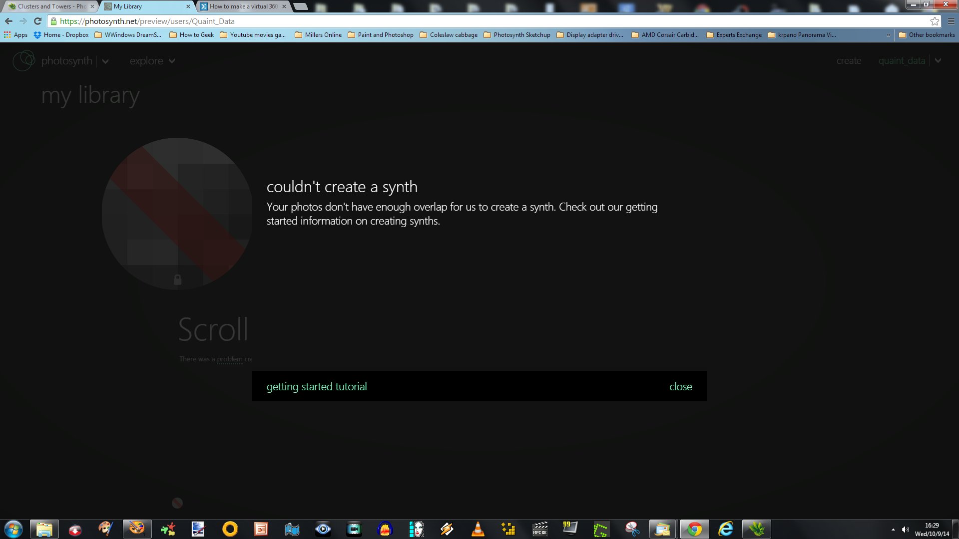
It cant be done with random images in Photosynth Shawn
using the scroll left and right directional or walk, , the images must overlap or sync together with the same height, I used three or 4 images from MTS-DeluxeDesigns that I felt looked the same in height and facing the front Photosynth allowed me to try and make a panorama with just the L+R walk and all the time one image was a problem so photosynth decides to omit whatever doesn't work.
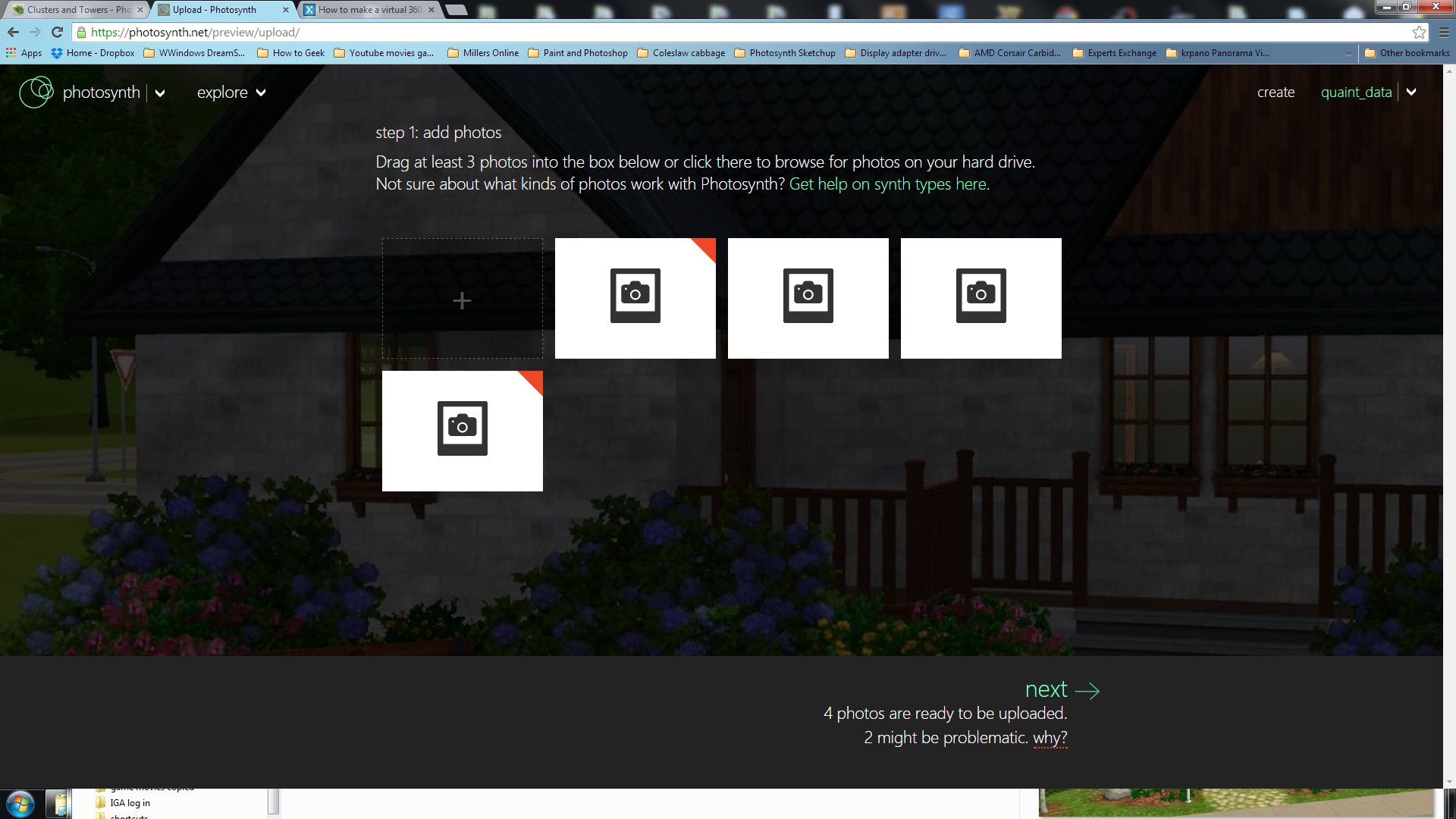
 Photosynth also wont allow a current Panorama made in MS Ice pity that
you are offered four choices once it accepts your images and there is no sense in choose 360 as it will just fail.
I used three
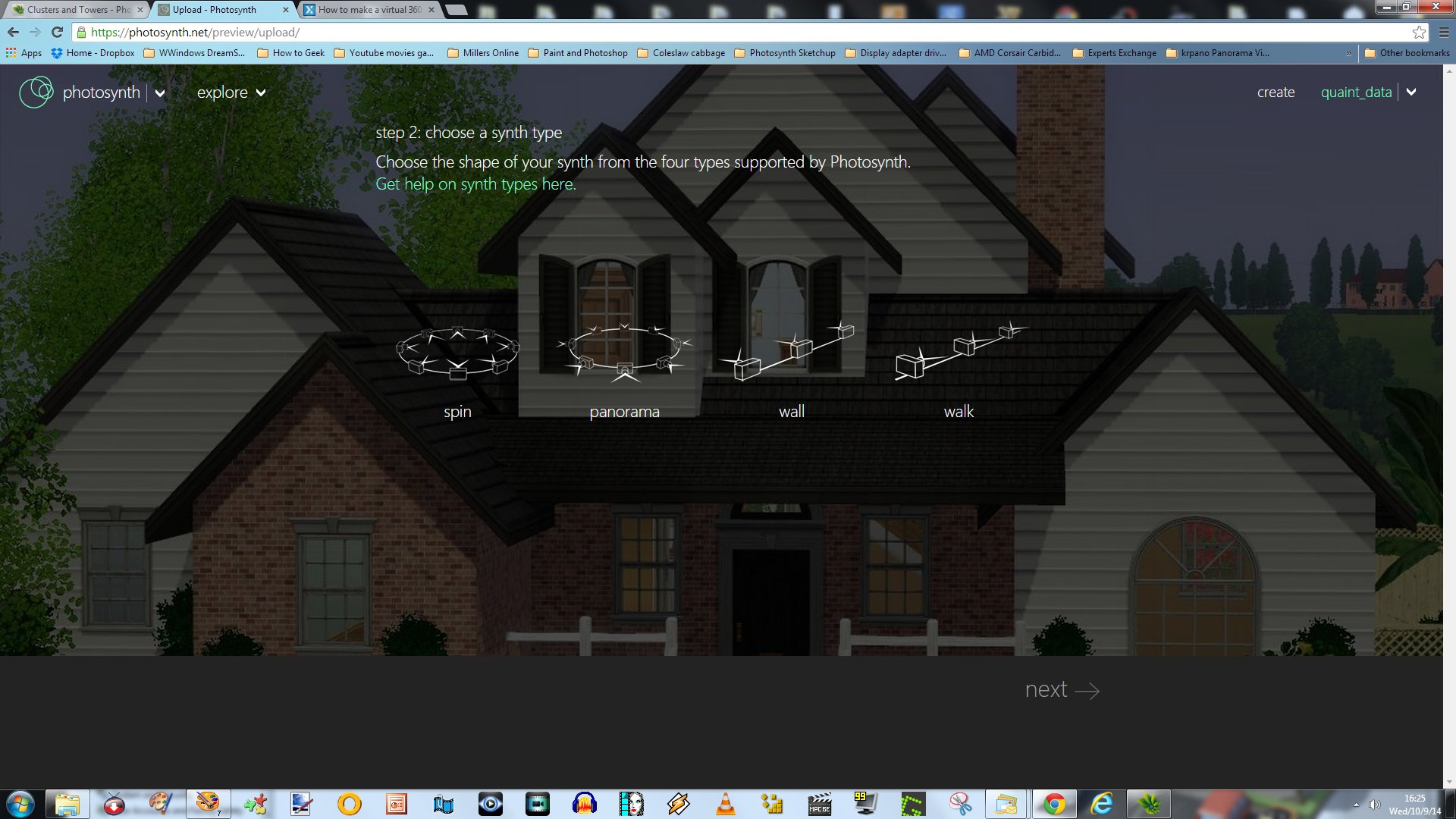 So I made another using my own Panorama photos taken of the mountains here using 3 photos and the it plays like a movie the synth chosen was wall
 The wall is probably your best choice for what you want to achieve.
three photos
https://photosynth.net/preview/view/0be102b7-205a-42cd-835b-20d543b9d474?startat=1
With the screenshots I guess I was off track and thought you wanted to use it in the game to collect some building snaps..
Even with XP it should work,
But in order to create a 360 degree panorama you need to take a set of photos 360 degrees with your camera and you standing there taking them, make sure they overlap a little and you should be good to go. 30 or 40 to create the spin
With the New Windows Phone this feature is already included inbuilt.
My Nikon when set to panorama/landscape it will show me on the screen where the photos line up so I can take a full 360 degrees accurately.
I don't wish to use private photos in the public world.
So my testing is it can't be done using those building images.
Get a FREE t-shirt when you ask your first question.
We believe in human intelligence. Our moderation policy strictly prohibits the use of LLM content in our Q&A threads.
https://photosynth.net/preview/?explore=all_time_favorites
Here's a 360 example
https://photosynth.net/preview/view/802c386c-110f-4bcf-bf7b-a4a18a4cc236
And you cannot save them to computer as they don't have an offline viewer.
They can only be shared.
Microsoft Ice will not stitch those images together from MTS-DeluxeDesigns
But do try Microsoft Ice ( image compositor) with a few images and choose your camera motion and orientation and angle then publish to Photosynth
http://www.pcpress.info/wp-content/uploads/2010/08/MicrosoftICE.png
http://winliveviews.wordpress.com/2010/03/11/image-composite-editor-ice-ver-1-3-3-from-microsoft-research-does-amazing-things/
What do you want achieve and for what purpose Shawn.
Is it online on a web page ( interactive)
for a video a game?
Or just illustrate something as we still do have the dreaded power point, I love PPS or windows moviemaker.
My problem is the interactive part? That requires that specific tool online. And the type of pictures you wish to use.
Creating panoramic virtual tours
Provide a 360 Degree 3D Panoramic Tour on Your Website
http://www.microsoft.com/web/solutions/photosynth.aspx
Now that you have a base understanding and what your limitations are lets try again with a new perspective.
You also have XP.
EARN REWARDS FOR ASKING, ANSWERING, AND MORE.
Earn free swag for participating on the platform.
Cheers
Shawn
Yes that instant streetview of Bruges worked fine for me...
That panorama of Feldkirch Austria is really something... amazing actually. Alas, I would still need the requisite overlapping photos to use that software.
Merete, you mentioned the "dreaded Powerpoint". Do you think I could do a rudimentary version of what I'm trying to do, with that? I've really never used Powerpoint. It would be more like a "slideshow", wouldn't it?
Lastly, your final idea about creating a actual physical model is a very good one, and one that has in fact, crossed my mind. That way, I wouldn't need multiple pictures of each building... just one good clear shot "face-on" of each one. Print it, cut it out and paste it on sturdy cardboard backing, and in this method physically "build" my model square. However another limitation I have would be one of physical space - I live in a very small apartment with not much room to spread out. But it's in an intriguing option for a solution... I just might try to make it work.
So the way I look at it now, I think I have a few options. From easiest to hardest, they would be:
(1) Physical "cardboard-cutout" model... then take photos as you described and build my 360 walkthrough pano from that.
(2) Pursue constructing 3D renderings of each individual building and then combine and arrange all those into my square. This will take a lot of time and work, as I know nothing about 3D software. There seems to be a free open-source software called "Blender" that I might be able to use for this. Would be a pretty big project for me.
... or the PowerPoint approach - depending on what your reply will be regarding that! ;-)
Thanks!
Shawn
(2)
Do you think I could do a rudimentary version of what I'm trying to do, with Power Point<< no not with what I know power point would create a power point show /slideshow. With what i know now it is definitely not suitable.
It wont give you interactive action only a slideshow with effects.
PPS files are PowerPoint Slide Show files made of images. These files automatically open in slide show/presentation mode and are viewable on any computer using the free PowerPoint Viewer.
PPT files are PowerPoint Presentation files made from a template and design. These files automatically open in edit mode when using the full Microsoft PowerPoint program.
Lots of free slideshow tools but they are just floating and scrolling image static.
The thing is these will not produce that walking into the image effect you seek.
The zoom into and zoom out will only be on image at a time.
In order to create this panorama there is some ingenuity required.
Even in a small room if you could get a circle of small tables that you could place your photos templates onto together then standing in the center take the complete circular set of images the more the better.
This may give you some of what you want to achieve.
It doesn't sound crazy either since you you wont be in the actual street.
The idea is to get the images sequenced on your camera.
Even placing images on a screen and snapping each will get the images onto your camera with seamless function.
3
I have used Blender but it is really an 3 D animation studio also not suitable.
http://en.wikibooks.org/wiki/Blender_3D:_Noob_to_Pro/Looking_All_Around_-_Panorama_Settings
As I see it your idea is sound but you want to use a proceedure that is not acceptable for this process..
In order to create this panorama you need a set of images that overlap.
I posted some god ideas here on previous question, check out the youtube videos
from below
Bullet Time Shot - Making of
https://www.youtube.com/watch?v=WDdxMBq2GW8
shoot video 3d effect around people dancing
https://www.experts-exchange.com/questions/28399912/shoot-video-3d-effect-around-people-dancing.html
PanoTools.org Wiki
http://wiki.panotools.org/
Turning still images into a time-lapse movie (tool to align images)
https://www.experts-exchange.com/questions/28413044/Turning-still-images-into-a-time-lapse-movie-tool-to-align-images.html
Get a FREE t-shirt when you ask your first question.
We believe in human intelligence. Our moderation policy strictly prohibits the use of LLM content in our Q&A threads.
Merete, have you ever heard of Google SketchUp? I did some googling and came across this site:
http://sketchupdate.blogspot.ca/2010_05_01_archive.html
About 1/2 way down that page is an article called "Announcing the Google Model Your Town Competition winner". Here it shows a 3D rendering of the town of Barranco, Peru by a fellow named Jorge De Albertis Bettocchi... with links to his blog. As soon as I saw this, I thought "This is EXACTLY what I'm looking for!!!" and got all excited thinking I'd found the solution. I did some more research about Sketchup and then because rather confused about some things:
- how did Mr. Bettochi actually render all these buildings? Did he walk around the town and take a million photos of each and every one... or are all these buildings already within Google Earth, and he just scooped them from there? (I have never used Google Earth and really know nothing about it... could all my desired Belgian buildings be residing, already-made, in Google Earth??).
- Is Sketchup currently a free program? It seems to cost about $600. And many of the links and videos I attempted to access were not available or dead links. Is the software still active?
- About 1/5th of the way down that same site I mention above, is an article called "Use your own photos in Building Maker". Upon reading about this "Building maker" plugin, this really seemed to confirm that Sketchup should do the job for me regarding applying flat phots to facades of buildings - rather easily. Only to find out that this plugin seems to be discontinued :-(
So although it first *seemed* that Sketchup might be the way to go, I'm now pretty confused about it. Could SketchUp + Google Earth be the solution to my problem??
Cheers
Shawn
I'm surprised you have never used Google Earth Street view, I mentioned this earlier in my first post and another about street view and how Google earth uses it.
- how did Mr. Bettochi actually render all these buildings? Did he walk around the town and take a million photos of each and every one... or are all these buildings already within Google Earth, and he just scooped them from there?<< yes he walked around in street view- 3D view and grabbed the building shots front and rear? and imported them in Sketchup.. using Google build Maker
Watch this one Shawn>>
3D Buildings Tutorials
Intro to Google Building Maker shows how he grabbed the buildings
http://www.google.com.au/earth/learn/3dbuildings.html
It is mentioned here and if you look at the real building and the modelled version he has loaded into his frame 3D model street in sketchup.
The purpose was to build a 3D model of your home town.
http://barranco3dproject.blogspot.com.au/
Google Earth
Beginner tutorials Advanced tutorials
http://www.google.com.au/earth/learn/beginner.html.
But sadly>>
Google build maker was retired in 2013
http://www.gearthblog.com/blog/archives/2013/03/google_will_be_discontinuing_the_bu.html
http://sketchucation.com/all-news/437-farewell-to-building-maker
SketchUp 8, should have it inbuilt with the new Style Builder
Quote
In SketchUp pro 8, Building Maker was already integrated into the software so one did not even need to leave SketchUp to access its features and immediately import the model for further tweaking.
600 bucks um well there goes the free stuff back to the drawing board
http://www.sketchup.com/products/sketchup-pro
Sketchup still has the free version but nolonger the building-maker.
Sorry.
Don't know where to go from here.
Regards Merete
One thing you wrote in your last post I didn't quite understand Merete:
"It is mentioned here and if you look at the real building and the modelled version he has loaded into his frame 3D model street in sketchup.
The purpose was to build a 3D model of your home town.
http://barranco3dproject.blogspot.com.au/"
I looked all through that site and I could not find where he mentions using "Building Maker". He does not seem to discuss his process anywhere on that page.
So anyway, I think with SketchUp + Google Earth, I should be off to a good start. And if I hit a dead-end with those tools, I can always use the "low-tech" alternative you suggested of just printing out the photos of the individual building, pasting them on some sturdy cardboard, and construct my own square,
Thanks!
Shawn
EARN REWARDS FOR ASKING, ANSWERING, AND MORE.
Earn free swag for participating on the platform.
https://www.youtube.com/watch?feature=player_embedded&v=CB_IpbPNT2A
It shows using sketchup with builder or so I believed and Google earth, he doesn't actually say it but the video shows it.
The images of the houses in real street view and the comparison shows sketchup and the builder it was just observation watching this video .
He is also using a lot of tools and had a lot of people help him from what I have digested, auto cad with Google 3D warehouse something called base camp which I only know of through my GPS.
I supposes he uses it to get a map of the city and see it on his computer, which basecamp software I have no idea.
I'd say he is using a few more tools but it's a lengthy process to read his blogs and have them translated.
Jorge also created a blog, Barranco 3D Project, that includes descriptions of his models, his modeling process, community involvement
http://sketchupdate.blogspot.com.au/2010/05/announcing-google-model-your-town.html
Google Sketchup 3D warehouse
http://en.softonic.com/s/google-sketchup-3d-warehouse-components-free-download?ab=1
http://help.sketchup.com/en/article/164179
How to download models from the 3DWarehouse onto SketchUp
https://www.youtube.com/watch?v=5m-a6SouHyw
To surmise, not that I have a full understanding how he modelled the houses, he took photos of the real town houses and built models of them and placed on to google earth in 3D street view, street view is a collection of images put together using Sketchup to create the virtual walk.
That's as far as my understanding is.
All the Best
.
Cheers
Shawn
Regards Merete
Get a FREE t-shirt when you ask your first question.
We believe in human intelligence. Our moderation policy strictly prohibits the use of LLM content in our Q&A threads.
Photos / Graphics Software
--
Questions
--
Followers
Top Experts
Photo and imaging software is used to edit and compose raster images; Adobe Photoshop dominates the market. Common actions include cropping, slicing, retouching, color replacement, masking and erasing. Other programs include GIMP, Serif PhotoPlus, Pixlr, PhotoScape, Picasa and IrfanView.