Programming
--
Questions
--
Followers
Top Experts
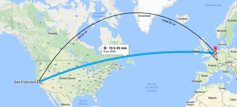
Flight distance vs. shortest distance
Stupid question, please see attached. When measuring the actual shortest distance between SFO to Amsterdam is shows 5,425mi. The airplane route shows longer 10k+ miles. Why wouldn't the flight goes the shortest distance? Or is it how the distance vs measurement shows on the map just for user's simplicity?

Zero AI Policy
We believe in human intelligence. Our moderation policy strictly prohibits the use of LLM content in our Q&A threads.
Get a world globe and attach the beginning and end point with a string. Note the path as if it were on the map projection you're using.
It's called a Great Circle Route and *is* the Shortest distance - if the string is tight! :-)
It's called a Great Circle Route and *is* the Shortest distance - if the string is tight! :-)
When measuring the actual shortest distance between SFO to Amsterdam is shows 5,425mi.Where did you get your "shortest distance"? Consider that it's nearly 4,000 miles from US coast to coast. Then there's the Atlantic Ocean to cross, etc. etc. So 5,425 SFO to Amsterdam???
ASKER CERTIFIED SOLUTION
membership
Log in or create a free account to see answer.
Signing up is free and takes 30 seconds. No credit card required.
SOLUTION
membership
Log in or create a free account to see answer.
Signing up is free and takes 30 seconds. No credit card required.
The greatest variable in airplane path other than air traffic control likelihoods and local deviations is likely the jet stream.
On a flight like the one you're looking at, the selection of flight path can make the difference in flight time (over the ground speed) of an hour. That's why west to east flight times are shorter than east to west.....
On a flight like the one you're looking at, the selection of flight path can make the difference in flight time (over the ground speed) of an hour. That's why west to east flight times are shorter than east to west.....
Another reason why a plane generally WON'T fly the "great circle" route (shortest distance) is that it is NOT a "constant bearing" route. Planes fly on a bearing, and why that bearing may change at certain points, in between those points you want the bearing to stay the same, so that pilots (and autopilots) can use their instruments to track that bearing.
Have a look at that "shortest distance" route. When projected on a map, it is curved. It starts out heading roughly north-east and finishes heading south-east, and gradually changes between the two heading throughout the entire route.
Have a look at that "shortest distance" route. When projected on a map, it is curved. It starts out heading roughly north-east and finishes heading south-east, and gradually changes between the two heading throughout the entire route.


EARN REWARDS FOR ASKING, ANSWERING, AND MORE.
Earn free swag for participating on the platform.
Programming
--
Questions
--
Followers
Top Experts
Programming includes both the specifics of the language you’re using, like Visual Basic, .NET, Java and others, but also the best practices in user experience and interfaces and the management of projects, version control and development. Other programming topics are related to web and cloud development and system and hardware programming.